-
, but the specific cultural significance of the sacred totemic site is not known. However, in an animist culture, offering ritual appeasement to the natural world and to hunted animals was centrally important, and it is likely the site served ceremonial purposes related to this goal. Remnants of stone dwellings and food caches can also be seen at the site, near the whale bone formations.")
Whalebone Alley, Yttygran Island, Chukotka, Bering Sea, Russia.
On Yttygran Island in the Bering Sea at a site currently known as "Whalebone Alley," numerous whale bones -- including skulls, jawbones, and ribs -- are placed in a lengthy alignment across the coastal plane at the back of a rocky beach. The bones are probably from bowhead whales. Archaeologists and ethnologists estimate the site dates to the ancient Eskimo society of the late Punuk period (13th and 14th centuries), but the specific cultural significance of the sacred totemic site is not known. However, in an animist culture, offering ritual appeasement to the natural world and to hunted animals was centrally important, and it is likely the site served ceremonial purposes related to this goal. Remnants of stone dwellings and food caches can also be seen at the site, near the whale bone formations.
-
, but the specific cultural significance of the sacred totemic site is not known. However, in an animist culture, offering ritual appeasement to the natural world and to hunted animals was centrally important, and it is likely the site served ceremonial purposes related to this goal. Remnants of stone dwellings and food caches can also be seen at the site, near the whale bone formations.")
Whalebone Alley, Yttygran Island, Chukotka, Bering Sea, Russia
On Yttygran Island in the Bering Sea at a site currently known as "Whalebone Alley," numerous whale bones -- including skulls, jawbones, and ribs -- are placed in a lengthy alignment across the coastal plane at the back of a rocky beach. The bones are probably from bowhead whales. Archaeologists and ethnologists estimate the site dates to the ancient Eskimo society of the late Punuk period (13th and 14th centuries), but the specific cultural significance of the sacred totemic site is not known. However, in an animist culture, offering ritual appeasement to the natural world and to hunted animals was centrally important, and it is likely the site served ceremonial purposes related to this goal. Remnants of stone dwellings and food caches can also be seen at the site, near the whale bone formations.
-
, sits high on the cliffs above the Bering Sea. Cape Dezhnev is the easternmost point on the Eurasian continent, and is situated directly across the Bering Strait from the United States. During the Cold War, the Soviets manned a military border outpost adjacent to the village site on this cape. Nearby there is also a monument honoring the Cosack explorer Semyon Dezhnev, the third Cook expedition, and the indigenous people.")
Ancient whale bone site, Cape Dezhnev, Chukotka, Bering Strait, Russia,.
The remains of an ancient Chukchi village and sacred site at Cape Dezhnev, including foundations of stone houses, food caches, and whale bones used for both practical and ritual purposes. The village site, estimated to be more than 500 years old (but was probably used by indigenous people until the mid-twentieth century), sits high on the cliffs above the Bering Sea. Cape Dezhnev is the easternmost point on the Eurasian continent, and is situated directly across the Bering Strait from the United States. During the Cold War, the Soviets manned a military border outpost adjacent to the village site on this cape. Nearby there is also a monument honoring the Cosack explorer Semyon Dezhnev, the third Cook expedition, and the indigenous people.
-
, sits high on the cliffs above the Bering Sea. Cape Dezhnev is the easternmost point on the Eurasian continent, and is situated directly across the Bering Strait from the United States. During the Cold War, the Soviets manned a military border outpost adjacent to the village site on this cape. Nearby there is also a monument honoring the Cosack explorer Semyon Dezhnev, the third Cook expedition, and the indigenous people.")
Ancient Chukchi village site, Cape Dezhnev, Chukotka, Bering Strait, Russia.
The remains of an ancient Chukchi village and sacred site at Cape Dezhnev, including foundations of stone houses, food caches, and whale bones used for both practical and ritual purposes. The village site, estimated to be more than 500 years old (but was probably used by indigenous people until the mid-twentieth century), sits high on the cliffs above the Bering Sea. Cape Dezhnev is the easternmost point on the Eurasian continent, and is situated directly across the Bering Strait from the United States. During the Cold War, the Soviets manned a military border outpost adjacent to the village site on this cape. Nearby there is also a monument honoring the Cosack explorer Semyon Dezhnev, the third Cook expedition, and the indigenous people.
-
, sits high on the cliffs above the Bering Sea. Cape Dezhnev is the easternmost point on the Eurasian continent, and is situated directly across the Bering Strait from the United States. During the Cold War, the Soviets manned a military/border outpost adjacent to the village site on this cape. Nearby there is also a monument honoring the Cosack explorer Semyon Dezhnev, the third Cook expedition, and the indigenous people. Cape Dezhnev, Chukotka, Siberia, Russia, Bering Strait.")
Ancient whale bone site, Cape Dezhnev, Chukotka, Bering Strait, Russia.
The remains of an ancient Chukchi village and sacred site at Cape Dezhnev, including foundations of stone houses, food caches, and whale bones used for practical purposes and arranged for rituals. The village site, estimated to be more than 500 years old (but was probably used by indigenous people until the mid-twentieth century), sits high on the cliffs above the Bering Sea. Cape Dezhnev is the easternmost point on the Eurasian continent, and is situated directly across the Bering Strait from the United States. During the Cold War, the Soviets manned a military/border outpost adjacent to the village site on this cape. Nearby there is also a monument honoring the Cosack explorer Semyon Dezhnev, the third Cook expedition, and the indigenous people. Cape Dezhnev, Chukotka, Siberia, Russia, Bering Strait.
-
, sits high on the cliffs above the Bering Sea. Cape Dezhnev is the easternmost point on the Eurasian continent, and is situated directly across the Bering Strait from the United States. During the Cold War, the Soviets manned a military border outpost adjacent to the village site on this cape. Nearby there is also a monument honoring the Cosack explorer Semyon Dezhnev, the third Cook expedition, and the indigenous people.")
Food cache at ancient Chukchi village site, Cape Dezhnev, Chukotka, Bering Straight, Russia
The remains of a stone food cache at an ancient Chukchi village site, with whale bones and driftwood logs draped across it, at Cape Dezhnev, Chukotka, Russia. In addition to food caches, the site includes foundations of stone houses, and whale bones arranged for both practical and ritual purposes. The village site, estimated to be more than 500 years old (but probably used by indigenous people until the mid-twentieth century), sits high on the cliffs above the Bering Sea. Cape Dezhnev is the easternmost point on the Eurasian continent, and is situated directly across the Bering Strait from the United States. During the Cold War, the Soviets manned a military border outpost adjacent to the village site on this cape. Nearby there is also a monument honoring the Cosack explorer Semyon Dezhnev, the third Cook expedition, and the indigenous people.
-

A monument high on the cliffs above the Bering Strait at Cape Dezhnev, honoring 17th century Cosack explorer Semyon Dezhnev, the third Cook expedition, and the indigenous people of the region. Chukotka Autonomous Okrug (Siberia), Russia.
Cape Dezhnev is the easternmost point of land on the Eurasian continent, and is situated directly across the Bering Strait from the United States. Semyon Dezhnev was the first recorded European to see the Cape, in 1648, and to determine that it marked the edge of the Eurasian continent. The remains of an ancient Chukchi village site are still perched on the cliffs at this cape. During the Cold War, the Soviets manned a military border outpost adjacent to the village site. Some ruins of the outpost still remain on the cliff.
-

Abandoned Buildings, Cape Dezhnev, Bering Sea, Russia.
Abandoned buildings at Cape Dezhnev, Chukotka, sit high above the Bering Strait in Russia. Cape Dezhnev is the easternmost point of land on the Eurasian continent, and is situated directly across the Bering Strait from the United States. It was a strategically-located Russian Cold War outpost, as well as a weather station and a Gulag. Now abandoned, the site has several crumbling buildings, a miscellaneous assortment of old equipment and 20th-century artifacts, and a monument to Semyon Dezhnyov -- the first recorded European to see the Cape and determine that it marked the edge of the Eurasian continent, in 1648. Prior to the early-to-mid 20th Century, Cape Dezhnev was used by indigenous people. Atop an oceanside cliff, there is a sacred site similar to Whale Bone Alley, where the bones of whales are ritually arranged; and nearby are the remains of ancient stone dwellings and food caches.
-

Detail of an abandoned building, Cape Dezhnev, Bering Strait, Russia
Detail of an abandoned Cold War era building at Cape Dezhnev, Chukotka, Russia. Cape Dezhnev is the easternmost point on the Eurasian continent, and is situated directly across the Bering Strait from the United States. It was a strategically-located Russian Cold War outpost, as well as a weather station and a Gulag. Now abandoned, the site has several crumbling buildings, a miscellaneous assortment of old equipment and 20th century artifacts, and a monument to Semyon Dezhnyov -- the first recorded European to see the Cape and determine that it marked the edge of the Eurasian continent, in 1648. Prior to the early-to-mid 20th Century, Cape Dezhnev was used by indigenous people. Atop an oceanside cliff, there is a sacred site similar to Whale Bone Alley, where the bones of whales are ritually arranged; and nearby are the remains of ancient stone house sites and food caches.
-

Abandoned Structures & Debris, Cape Dezhnev, Bering Strait, Russia
Abandoned structures, historical artifacts, and debris at Cape Dezhnev, Chukotka, Russia. Cape Dezhnev is the easternmost point on the Eurasian continent, and is situated directly across the Bering Strait from the United States. It was a strategically-located Russian Cold War outpost, as well as a weather station and a Gulag. Now abandoned, the site has several crumbling buildings, a miscellaneous assortment of old equipment and 20th Century artifacts, and a monument to Semyon Dezhnyov -- the first recorded European to see the Cape and determine that it marked the edge of the Eurasian continent, in 1648. Prior to the early-to-mid 20th Century, Cape Dezhnev was used by indigenous people. Atop an oceanside cliff, there is a sacred site similar to Whale Bone Alley, where the bones of whales are ritually arranged; and nearby are the remains of ancient stone house sites and food caches.
-
 -- after the meat, blubber, tusks, some bones, and most of the skin have been removed -- lying on a rocky beach at the shore of the Bering Sea on Arakamchechen Island, Chukotka, Russia. The walrus was killed by indigenous hunters from a nearby village who are allocated an annual subsistence quota.")
Pacific Walrus carcass, Arakamchechen Island, Chukotka, Bering Sea, Russia.
The carcass of a recently-killed Pacific Walrus (Odobenus rosmarus divergens) -- after the meat, blubber, tusks, some bones, and most of the skin have been removed -- lying on a rocky beach at the shore of the Bering Sea on Arakamchechen Island, Chukotka, Russia. The walrus was killed by indigenous hunters from a nearby village who are allocated an annual subsistence quota.
-
 -- after the meat, blubber, tusks, some bones, and most of the skin have been removed -- lying on a rocky beach at the shore of the Bering Sea on Arakamchechen Island, Chukotka, Russia. The walrus was killed by indigenous hunters from a nearby village who are allocated an annual subsistence quota.")
Pacific Walrus carcass, Arakamchechen Island, Chukotka, Bering Sea, Russia
The carcass of a recently-killed Pacific Walrus (Odobenus rosmarus divergens) -- after the meat, blubber, tusks, some bones, and most of the skin have been removed -- lying on a rocky beach at the shore of the Bering Sea on Arakamchechen Island, Chukotka, Russia. The walrus was killed by indigenous hunters from a nearby village who are allocated an annual subsistence quota.
-
, Russia. Nansen and Johansen spent eight months in a primitive hut here, following their failed attempt to reach the North Pole and prior to their rescue by Frederick Jackson at Cape Flora on Northbrook Island. This area is within Russkaya Arktika National Park (Russian Arctic National Park) established by then-Prime Minister Vladimir Putin by decree in June 2009 and officially opened in summer 2011.")
Memorial plaque at Cape Norwegia, Jackson Island, Franz Josef Land, Russia.
A memorial plaque commemorates the over-wintering site of Arctic explorers Fridtjof Nansen and Hjalmar Johansen in 1895-96 at Cape Norwegia on Jackson Island in the Franz Josef Land archipelago, Barents Sea (Arctic Ocean), Russia. Nansen and Johansen spent eight months in a primitive hut here, following their failed attempt to reach the North Pole and prior to their rescue by Frederick Jackson at Cape Flora on Northbrook Island. This area is within Russkaya Arktika National Park (Russian Arctic National Park) established by then-Prime Minister Vladimir Putin by decree in June 2009 and officially opened in summer 2011.
-
, Russia. Nansen and Johansen spent eight months in a primitive hut here, following their failed attempt to reach the North Pole and prior to their rescue by Frederick Jackson at Cape Flora on Northbrook Island. This area is within Russkaya Arktika National Park (Russian Arctic National Park) established by then-Prime Minister Vladimir Putin by decree in June 2009 and officially opened in summer 2011.")
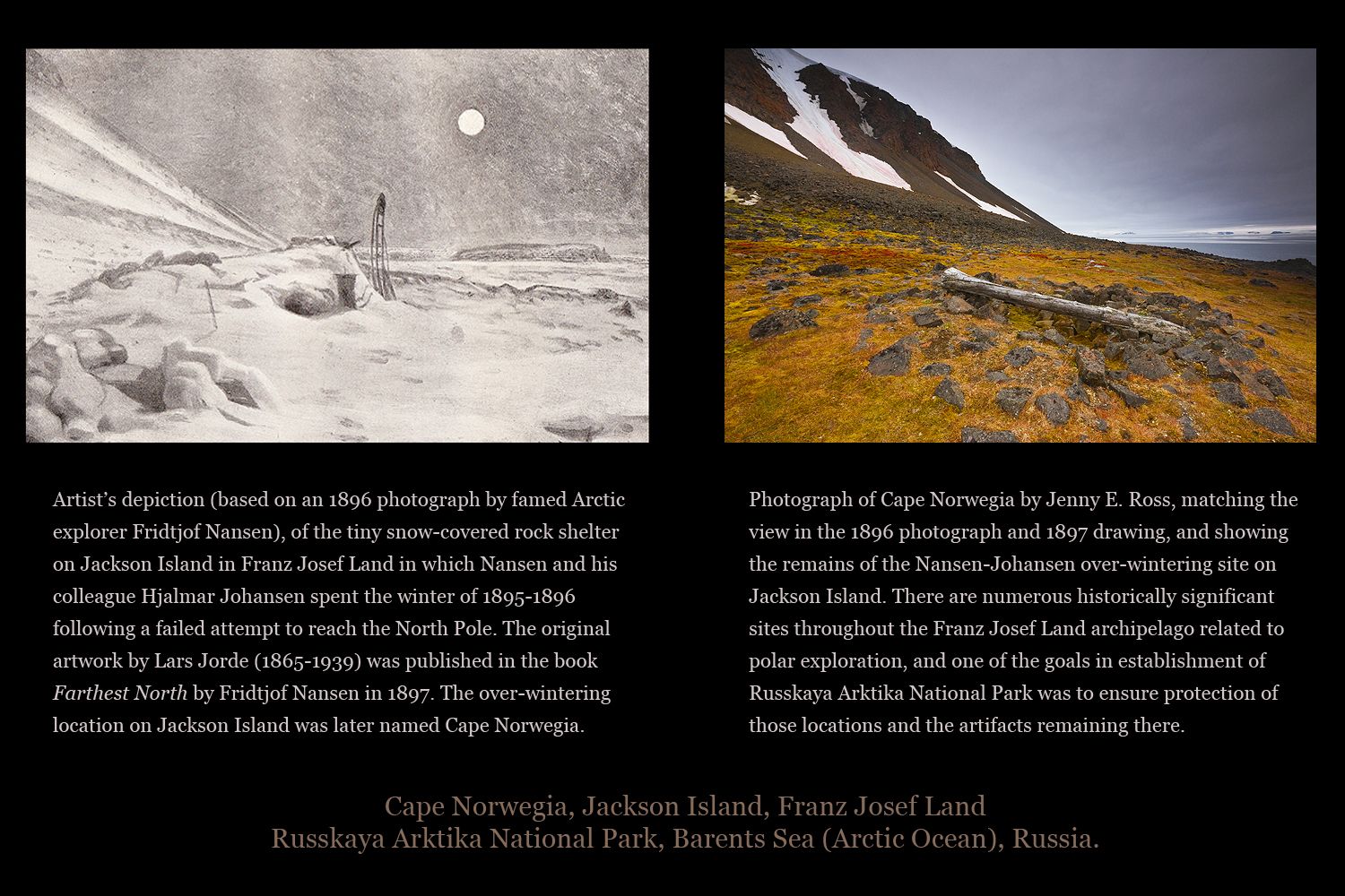
Cape Norwegia, Jackson Island, Franz Josef Land, Russia
The over-wintering site of Arctic explorers Fridtjof Nansen and Hjalmar Johansen in 1895-96 at Cape Norwegia on Jackson Island in the Franz Josef Land archipelago, Barents Sea (Arctic Ocean), Russia. Nansen and Johansen spent eight months in a primitive hut here, following their failed attempt to reach the North Pole and prior to their rescue by Frederick Jackson at Cape Flora on Northbrook Island. This area is within Russkaya Arktika National Park (Russian Arctic National Park) established by then-Prime Minister Vladimir Putin by decree in June 2009 and officially opened in summer 2011.
-
![]()
-
, Russia. This site was used by two Arctic exploration expeditions -- the Baldwin-Ziegler Expedition (1901-02) and the Fiala-Ziegler Expedition (1903-05). The research base originally had two cabins, kennels for 420 sledge dogs, stables for 15 ponies, a weather station, and an astronomic observatory. This location is within Russkaya Arktika National Park (Russian Arctic National Park).")
Arctic expedition relics, Camp Ziegler, Alger Island, Franz Josef Land, Russia.
The disintegrating remains of an important Arctic expedition base, Camp Ziegler, near the shore of Alger Island in Franz Josef Land, Barents Sea (Arctic Ocean), Russia. This site was used by two Arctic exploration expeditions -- the Baldwin-Ziegler Expedition (1901-02) and the Fiala-Ziegler Expedition (1903-05). The research base originally had two cabins, kennels for 420 sledge dogs, stables for 15 ponies, a weather station, and an astronomic observatory. This location is within Russkaya Arktika National Park (Russian Arctic National Park).
-
, Russia. This area is within Russkaya Arktika National Park (Russian Arctic National Park) established by then-Prime Minister Vladimir Putin by decree in June 2009 and officially opened in summer 2011.")
Relics of Arctic exploration, Cape Flora, Northbrook Island, Franz Josef Land, Russia.
Historically significant remains of the 1894 Fiala-Ziegler expedition cabin and the 1894-97 Jackson-Harmsworth expedition camp, as well as the site of the 1881-82 Eira Camp of the Smith Expedition, Cape Flora, Northbrook Island, Franz Josef Land, Barents Sea (Arctic Ocean), Russia. This area is within Russkaya Arktika National Park (Russian Arctic National Park) established by then-Prime Minister Vladimir Putin by decree in June 2009 and officially opened in summer 2011.
-
, Russia.")
George Land, Franz Josef Land, Russia.
An Arctic expedition ship lies at anchor next to the ice-covered edge of George Land, in the Franz Josef Land archipelago, Barents Sea (Arctic Ocean), Russia.
-
 within the Franz Josef Land archipelago, Barents Sea (Arctic Ocean), Russia. This location was first used as an wintering base by the failed North Pole expedition of Georgiy Sedov in 1913-14. Subsequently it became the site of the first permanent Soviet base to be installed in the Franz Josef Land archipelago. It was in uninterrupted year-round use by 20-50 people from 1929 to 1959. Following its abandonment as a permanent station in 1959, its buildings and equipment were left to disintegrate. In the early 1990's a few buildings were partially renovated and have occasionally been used since then by Russian scientists as a summer research base. Several grave sites from the Soviet era and from the era of exploration, including Sedov's, are near the disintegrating station. This location is within Russkaya Arktika National Park (Russian Arctic National Park).")
Relics at Tikhaya Station, Hooker Island, Franz Josef Land, Russia.
The remains of Tikhaya Station on Hooker Island in Tikhaja Bukhta (Calm Bay) within the Franz Josef Land archipelago, Barents Sea (Arctic Ocean), Russia. This location was first used as an wintering base by the failed North Pole expedition of Georgiy Sedov in 1913-14. Subsequently it became the site of the first permanent Soviet base to be installed in the Franz Josef Land archipelago. It was in uninterrupted year-round use by 20-50 people from 1929 to 1959. Following its abandonment as a permanent station in 1959, its buildings and equipment were left to disintegrate. In the early 1990's a few buildings were partially renovated and have occasionally been used since then by Russian scientists as a summer research base. Several grave sites from the Soviet era and from the era of exploration, including Sedov's, are near the disintegrating station. This location is within Russkaya Arktika National Park (Russian Arctic National Park).
-
 within the Franz Josef Land archipelago, Barents Sea (Arctic Ocean), Russia. This location was first used as an wintering base by the failed North Pole expedition of Georgiy Sedov in 1913-14. Subsequently it became the site of the first permanent Soviet base to be installed in the Franz Josef Land archipelago. It was in uninterrupted year-round use by 20-50 people from 1929 to 1959. Following its abandonment as a permanent station in 1959, its buildings and equipment were left to disintegrate. In the early 1990's a few buildings were partially renovated and have occasionally been used since then by Russian scientists as a summer research base. Several grave sites from the Soviet era and from the era of exploration, including Sedov's, are near the disintegrating station. This location is within Russkaya Arktika National Park (Russian Arctic National Park).")
Relics at Tikhaya Station, Hooker Island, Franz Josef Land, Russia.
The ruins of an early 20th-century airplane hangar at Tikhaya Station on Hooker Island in Tikhaja Bukhta (Calm Bay) within the Franz Josef Land archipelago, Barents Sea (Arctic Ocean), Russia. This location was first used as an wintering base by the failed North Pole expedition of Georgiy Sedov in 1913-14. Subsequently it became the site of the first permanent Soviet base to be installed in the Franz Josef Land archipelago. It was in uninterrupted year-round use by 20-50 people from 1929 to 1959. Following its abandonment as a permanent station in 1959, its buildings and equipment were left to disintegrate. In the early 1990's a few buildings were partially renovated and have occasionally been used since then by Russian scientists as a summer research base. Several grave sites from the Soviet era and from the era of exploration, including Sedov's, are near the disintegrating station. This location is within Russkaya Arktika National Park (Russian Arctic National Park).
-
 within the Franz Josef Land archipelago, Barents Sea (Arctic Ocean), Russia. This location was first used as an wintering base by the failed North Pole expedition of Georgiy Sedov in 1913-14. Subsequently it became the site of the first permanent Soviet base to be installed in the Franz Josef Land archipelago. It was in uninterrupted year-round use by 20-50 people from 1929 to 1959. Following its abandonment as a permanent station in 1959, its buildings and equipment were left to disintegrate. In the early 1990's a few buildings were partially renovated and have occasionally been used since then by Russian scientists as a summer research base. Several grave sites from the Soviet era and from the era of exploration, including Sedov's, are near the disintegrating station. This location is within Russkaya Arktika National Park (Russian Arctic National Park).")
Relics at Tikhaya Station, Hooker Island, Franz Josef Land, Russia.
The remains of Tikhaya Station on Hooker Island in Tikhaja Bukhta (Calm Bay) within the Franz Josef Land archipelago, Barents Sea (Arctic Ocean), Russia. This location was first used as an wintering base by the failed North Pole expedition of Georgiy Sedov in 1913-14. Subsequently it became the site of the first permanent Soviet base to be installed in the Franz Josef Land archipelago. It was in uninterrupted year-round use by 20-50 people from 1929 to 1959. Following its abandonment as a permanent station in 1959, its buildings and equipment were left to disintegrate. In the early 1990's a few buildings were partially renovated and have occasionally been used since then by Russian scientists as a summer research base. Several grave sites from the Soviet era and from the era of exploration, including Sedov's, are near the disintegrating station. This location is within Russkaya Arktika National Park (Russian Arctic National Park).
-
 within the Franz Josef Land archipelago, Barents Sea (Arctic Ocean), Russia. This location was first used as an wintering base by the failed North Pole expedition of Georgiy Sedov in 1913-14. Subsequently it became the site of the first permanent Soviet base to be installed in the Franz Josef Land archipelago. It was in uninterrupted year-round use by 20-50 people from 1929 to 1959. Following its abandonment as a permanent station in 1959, its buildings and equipment were left to disintegrate. In the early 1990's a few buildings were partially renovated and have occasionally been used since then by Russian scientists as a summer research base. Several grave sites from the Soviet era and from the era of exploration, including Sedov's, are near the disintegrating station. This location is within Russkaya Arktika National Park (Russian Arctic National Park).")
Relics at Tikhaya Station, Hooker Island, Franz Josef Land, Russia.
The remains of Tikhaya Station on Hooker Island in Tikhaja Bukhta (Calm Bay) within the Franz Josef Land archipelago, Barents Sea (Arctic Ocean), Russia. This location was first used as an wintering base by the failed North Pole expedition of Georgiy Sedov in 1913-14. Subsequently it became the site of the first permanent Soviet base to be installed in the Franz Josef Land archipelago. It was in uninterrupted year-round use by 20-50 people from 1929 to 1959. Following its abandonment as a permanent station in 1959, its buildings and equipment were left to disintegrate. In the early 1990's a few buildings were partially renovated and have occasionally been used since then by Russian scientists as a summer research base. Several grave sites from the Soviet era and from the era of exploration, including Sedov's, are near the disintegrating station. This location is within Russkaya Arktika National Park (Russian Arctic National Park).
-
, Russia. This area is within Russkaya Arktika National Park (Russian Arctic National Park) established by then-Prime Minister Vladimir Putin by decree in June 2009 and officially opened in summer 2011. Since this photograph was taken, the Russian government has made focused efforts to clean up contaminated sites like this that are scattered throughout the Russian High Arctic.")
Abandoned oil drums, Cape Flora, Northbrook Island, Franz Josef Land, Russia.
Old abandoned oil drums contaminate the soil and despoil the otherwise pristine Arctic landscape at Cape Flora on Northbrook Island in the Franz Josef Land archipelago, Barents Sea (Arctic Ocean), Russia. This area is within Russkaya Arktika National Park (Russian Arctic National Park) established by then-Prime Minister Vladimir Putin by decree in June 2009 and officially opened in summer 2011. Since this photograph was taken, the Russian government has made focused efforts to clean up contaminated sites like this that are scattered throughout the Russian High Arctic.
-
, Russia. Once a remote outpost that was home to approximately 200 people, Ushakovskoye Village was abandoned in 1997. A portion of the village is still used by park rangers as the headquarters for the Wrangel State Nature Reserve, which is also a UNESCO World Heritage Site. Remaining relics, debris and contaminated items such as abandoned and leaking oil drums are in the process of being removed from the island pursuant to a comprehensive and very costly clean-up program initiated by the Russian government in 2011.")
Abandoned navigation and weather station, Wrangel Island, Chukchi Sea, Russia.
A Soviet-era navigation and weather station sits abandoned on Rogers Bay spit near Ushakovkoye Village on Wrangel Island in the Chukchi Sea (Arctic Ocean), Russia. Once a remote outpost that was home to approximately 200 people, Ushakovskoye Village was abandoned in 1997. A portion of the village is still used by park rangers as the headquarters for the Wrangel State Nature Reserve, which is also a UNESCO World Heritage Site. Remaining relics, debris and contaminated items such as abandoned and leaking oil drums are in the process of being removed from the island pursuant to a comprehensive and very costly clean-up program initiated by the Russian government in 2011.
-
, Russia. Once a remote outpost that was home to approximately 200 people, Ushakovskoye Village was abandoned in 1997. A portion of the village is still used by park rangers as the headquarters for the Wrangel State Nature Reserve, which is also a UNESCO World Heritage Site. Remaining debris and contaminated items such as abandoned and leaking oil drums are in the process of being removed from the island pursuant to a comprehensive and very costly clean-up program initiated by the Russian government in 2011.")
Ruins at Ushakovskoye Village, Wrangel Island, Rogers Bay, Chukchi Sea, Russia.
Abandoned and disintegrating buildings, historical artifacts, and debris lie scattered across the landscape at Ushakovskoye Village on Wrangel Island in Rogers Bay, Chukchi Sea (Arctic Ocean), Russia. Once a remote outpost that was home to approximately 200 people, Ushakovskoye Village was abandoned in 1997. A portion of the village is still used by park rangers as the headquarters for the Wrangel State Nature Reserve, which is also a UNESCO World Heritage Site. Remaining debris and contaminated items such as abandoned and leaking oil drums are in the process of being removed from the island pursuant to a comprehensive and very costly clean-up program initiated by the Russian government in 2011.
-

Ruins at Ushakovskoye Village, Wrangel Island, Rogers Bay, Chukchi Sea, Russia
Abandoned and disintegrating buildings and old oil drums are scattered across the landscape at Ushakovskoye Village on Wrangel Island in Rogers Bay, Chukchi Sea, Russia. Once a remote outpost that was home to approximately 200 people, Ushakovskoye Village was abandoned in 1997. A portion of the village is still used by park rangers as the headquarters for the Wrangel State Nature Reserve, which is also a UNESCO World Heritage Site. Remaining debris and contaminated items such as abandoned and leaking oil drums are in the process of being removed from the island pursuant to a comprehensive and very costly clean-up program initiated by the Russian government in 2011.
-
 in the Bering Sea. Provideniya is within Russia's Chukotka Autonomous Okrug. With the northernmost Russian deep-water harbor in the Bering Sea, Provideniya has long served as a port for Russian ships traveling to and from the Northeast Passage and Murmansk. It is sometimes referred to as Russia's \"Doorway to the Arctic.\" Provideniya is located across the Bering Strait from Alaska, very near the International Date Line. Due to its proximity to the U.S., Provideniya had a strategically important Russian military installation during the Cold War (1945-1991). In that period, the population of the town swelled to approximately 15,000 people, but now there are only about 2,000 residents remaining. There is just one main street, and many Soviet-era buildings are abandoned and crumbling. Power for Provideniya is generated by a coal-burning power plant located on the town's main street.")
Provideniya, Chukotka, Bering Sea, Russia.
An early morning view of Provideniya from Komsoloskaya Bay (a part of Provideniya Bay) in the Bering Sea. Provideniya is within Russia's Chukotka Autonomous Okrug. With the northernmost Russian deep-water harbor in the Bering Sea, Provideniya has long served as a port for Russian ships traveling to and from the Northeast Passage and Murmansk. It is sometimes referred to as Russia's "Doorway to the Arctic." Provideniya is located across the Bering Strait from Alaska, very near the International Date Line. Due to its proximity to the U.S., Provideniya had a strategically important Russian military installation during the Cold War (1945-1991). In that period, the population of the town swelled to approximately 15,000 people, but now there are only about 2,000 residents remaining. There is just one main street, and many Soviet-era buildings are abandoned and crumbling. Power for Provideniya is generated by a coal-burning power plant located on the town's main street.
-
 in the Bering Sea. It is within Russia's Chukotka Autonomous Okrug. With the northernmost Russian deep-water harbor in the Bering Sea, Provideniya has long served as a port for Russian ships traveling to and from the Northeast Passage and Murmansk. It is sometimes referred to as Russia's \"Doorway to the Arctic.\" Provideniya is located across the Bering Strait from Alaska, very near the International Date Line. Due to its proximity to the U.S., Provideniya had a strategically important Russian military installation during the Cold War (1945-1991). In that period, the population of the town swelled to approximately 15,000 people, but now there are only about 2,000 residents remaining. There is just one main street, and many Soviet-era buildings are abandoned and crumbling. Power for Provideniya is generated by a coal-burning power plant located on the main street.")
Provideniya, Chukotka, Bering Sea, Russia.
A view of the main street in Provideniya, Russia. Provideniya is situated at the edge of Komsoloskaya Bay (a part of Provideniya Bay) in the Bering Sea. It is within Russia's Chukotka Autonomous Okrug. With the northernmost Russian deep-water harbor in the Bering Sea, Provideniya has long served as a port for Russian ships traveling to and from the Northeast Passage and Murmansk. It is sometimes referred to as Russia's "Doorway to the Arctic." Provideniya is located across the Bering Strait from Alaska, very near the International Date Line. Due to its proximity to the U.S., Provideniya had a strategically important Russian military installation during the Cold War (1945-1991). In that period, the population of the town swelled to approximately 15,000 people, but now there are only about 2,000 residents remaining. There is just one main street, and many Soviet-era buildings are abandoned and crumbling. Power for Provideniya is generated by a coal-burning power plant located on the main street.
-
 in the Bering Sea, and is within Russia's Chukotka Autonomous Okrug. With the northernmost Russian deep-water harbor in the Bering Sea, Provideniya has long served as a port for Russian ships traveling to and from the Northeast Passage and Murmansk. It is located across the Bering Strait from Alaska, very near the International Date Line. Due to its proximity to the U.S., Provideniya had a strategically important Russian military installation during the Cold War (1945-1991). In that period, the population of the town swelled to approximately 15,000 people, but now there are only about 2,000 residents remaining. There is just one main street, and many Soviet-era buildings are abandoned and crumbling.")
Coal-fired power and coal ash in Provideniya, Chukotka, Russia.
Coal ash from a coal-fired power plant is piled on the ground and used as aggregate on roadways in the town of Provideniya, Russia. Provideniya is situated at the shore of Komsoloskaya Bay (a part of Provideniya Bay) in the Bering Sea, and is within Russia's Chukotka Autonomous Okrug. With the northernmost Russian deep-water harbor in the Bering Sea, Provideniya has long served as a port for Russian ships traveling to and from the Northeast Passage and Murmansk. It is located across the Bering Strait from Alaska, very near the International Date Line. Due to its proximity to the U.S., Provideniya had a strategically important Russian military installation during the Cold War (1945-1991). In that period, the population of the town swelled to approximately 15,000 people, but now there are only about 2,000 residents remaining. There is just one main street, and many Soviet-era buildings are abandoned and crumbling.
-
 in the Bering Sea. Provideniya is within Russia's Chukotka Autonomous Okrug. With the northernmost Russian deep-water harbor in the Bering Sea, Provideniya has long served as a port for Russian ships traveling to and from the Northeast Passage and Murmansk. It is located across the Bering Strait from Alaska, close to the International Date Line. Due to its proximity to the U.S., Provideniya had a strategically important Russian military installation during the Cold War (1945-1991). In that period, the population of the town swelled to approximately 15,000 people; but now there are only about 2,000 residents remaining. There is just one main street, and many Soviet-era buildings are abandoned and crumbling. Power for Provideniya is generated by a coal-burning power plant located on the town's main street.")
Coal and coal ash, Port of Provideniya, Chukotka, Bering Sea, Russia.
Large piles of coal and coal ash lie on the ground at the Port of Provideniya, very close to the water's edge, at the shore of Komsoloskaya Bay (a part of Provideniya Bay) in the Bering Sea. Provideniya is within Russia's Chukotka Autonomous Okrug. With the northernmost Russian deep-water harbor in the Bering Sea, Provideniya has long served as a port for Russian ships traveling to and from the Northeast Passage and Murmansk. It is located across the Bering Strait from Alaska, close to the International Date Line. Due to its proximity to the U.S., Provideniya had a strategically important Russian military installation during the Cold War (1945-1991). In that period, the population of the town swelled to approximately 15,000 people; but now there are only about 2,000 residents remaining. There is just one main street, and many Soviet-era buildings are abandoned and crumbling. Power for Provideniya is generated by a coal-burning power plant located on the town's main street.
-
 in the Bering Sea. It is within Russia's Chukotka Autonomous Okrug. With the northernmost Russian deep-water harbor in the Bering Sea, Provideniya has long served as a port for Russian ships traveling to and from the Northeast Passage and Murmansk. It is sometimes referred to as Russia's \"Doorway to the Arctic.\" Provideniya is located across the Bering Strait from Alaska, very near the International Date Line. Due to its proximity to the U.S., Provideniya had a strategically important Russian military installation during the Cold War (1945-1991). In that period, the population of the town swelled to approximately 15,000 people, but now there are only about 2,000 residents remaining. There is just one main street, and many Soviet-era buildings are dilapidated, abandoned, and crumbling.")
Abandoned building, Provideniya, Chukotka, Russia.
Detail of an abandoned Soviet-era building in Provideniya, Russia. Provideniya is situated at the edge of Komsoloskaya Bay (a part of Provideniya Bay) in the Bering Sea. It is within Russia's Chukotka Autonomous Okrug. With the northernmost Russian deep-water harbor in the Bering Sea, Provideniya has long served as a port for Russian ships traveling to and from the Northeast Passage and Murmansk. It is sometimes referred to as Russia's "Doorway to the Arctic." Provideniya is located across the Bering Strait from Alaska, very near the International Date Line. Due to its proximity to the U.S., Provideniya had a strategically important Russian military installation during the Cold War (1945-1991). In that period, the population of the town swelled to approximately 15,000 people, but now there are only about 2,000 residents remaining. There is just one main street, and many Soviet-era buildings are dilapidated, abandoned, and crumbling.
-
 in the Bering Sea. It is within Russia's Chukotka Autonomous Okrug. With the northernmost Russian deep-water harbor in the Bering Sea, Provideniya has long served as a port for Russian ships traveling to and from the Northeast Passage and Murmansk. It is sometimes referred to as Russia's \"Doorway to the Arctic.\" Provideniya is located across the Bering Strait from Alaska, very near the International Date Line. Due to its proximity to the U.S., Provideniya had a strategically important Russian military installation during the Cold War (1945-1991). In that period, the population of the town swelled to approximately 15,000 people, but now there are only about 2,000 residents remaining. There is just one main street, and many Soviet-era buildings are dilapidated, abandoned, and crumbling.")
Abandoned building, Provideniya, Chukotka, Russia.
Detail of an abandoned building in Provideniya, Russia. Provideniya is situated at the edge of Komsoloskaya Bay (a part of Provideniya Bay) in the Bering Sea. It is within Russia's Chukotka Autonomous Okrug. With the northernmost Russian deep-water harbor in the Bering Sea, Provideniya has long served as a port for Russian ships traveling to and from the Northeast Passage and Murmansk. It is sometimes referred to as Russia's "Doorway to the Arctic." Provideniya is located across the Bering Strait from Alaska, very near the International Date Line. Due to its proximity to the U.S., Provideniya had a strategically important Russian military installation during the Cold War (1945-1991). In that period, the population of the town swelled to approximately 15,000 people, but now there are only about 2,000 residents remaining. There is just one main street, and many Soviet-era buildings are dilapidated, abandoned, and crumbling.
-
 in the Bering Sea. It is within Russia's Chukotka Autonomous Okrug. With the northernmost Russian deep-water harbor in the Bering Sea, Provideniya has long served as a port for Russian ships traveling to and from the Northeast Passage and Murmansk. Provideniya is located across the Bering Strait from Alaska, very near the International Date Line. Due to its proximity to the U.S., Provideniya had a strategically important Russian military installation during the Cold War (1945-1991). In that period, the population of the town swelled to approximately 15,000 people, but now there are only about 2,000 residents remaining. There is just one main street, and many Soviet-era buildings are abandoned and crumbling. In an attempt to mitigate the grim surroundings, the government has recently brightened some buildings with colorful paint,")
Residential building, Provideniya, Chukotka, Russia
Detail of a residential building in Provideniya, Chukotka, Siberia, Russia. Provideniya is situated at the edge of Komsoloskaya Bay (a part of Provideniya Bay) in the Bering Sea. It is within Russia's Chukotka Autonomous Okrug. With the northernmost Russian deep-water harbor in the Bering Sea, Provideniya has long served as a port for Russian ships traveling to and from the Northeast Passage and Murmansk. Provideniya is located across the Bering Strait from Alaska, very near the International Date Line. Due to its proximity to the U.S., Provideniya had a strategically important Russian military installation during the Cold War (1945-1991). In that period, the population of the town swelled to approximately 15,000 people, but now there are only about 2,000 residents remaining. There is just one main street, and many Soviet-era buildings are abandoned and crumbling. In an attempt to mitigate the grim surroundings, the government has recently brightened some buildings with colorful paint,
-
, Russia. Provideniya is situated at the edge of Komsoloskaya Bay (a part of Provideniya Bay) in the Bering Sea. With the northernmost Russian deep-water harbor in the Bering Sea, Provideniya has long served as a port for Russian ships traveling to and from the Northeast Passage and Murmansk. Provideniya is located across the Bering Strait from Alaska, very near the International Date Line. Due to its proximity to the U.S., Provideniya had a strategically important Russian military installation during the Cold War (1945-1991). In that period, the population of the town swelled to approximately 15,000 people, but now there are only about 2,000 residents remaining. There is just one main street, and many Soviet-era buildings are abandoned and crumbling. In an attempt to mitigate the grim surroundings, the government has recently brightened some buildings with colorful paint,")
Buildings in Provideniya, Chukotka, Russia.
A view of old dilapidated structures and newly painted buildings in Provideniya, Chukotka (Siberia), Russia. Provideniya is situated at the edge of Komsoloskaya Bay (a part of Provideniya Bay) in the Bering Sea. With the northernmost Russian deep-water harbor in the Bering Sea, Provideniya has long served as a port for Russian ships traveling to and from the Northeast Passage and Murmansk. Provideniya is located across the Bering Strait from Alaska, very near the International Date Line. Due to its proximity to the U.S., Provideniya had a strategically important Russian military installation during the Cold War (1945-1991). In that period, the population of the town swelled to approximately 15,000 people, but now there are only about 2,000 residents remaining. There is just one main street, and many Soviet-era buildings are abandoned and crumbling. In an attempt to mitigate the grim surroundings, the government has recently brightened some buildings with colorful paint,
-
 in the Bering Sea. It is within Russia's Chukotka Autonomous Okrug. With the northernmost Russian deep-water harbor in the Bering Sea, Provideniya has long served as a port for Russian ships traveling to and from the Northeast Passage and Murmansk. It is sometimes referred to as Russia's \"Doorway to the Arctic.\" Provideniya is located across the Bering Strait from Alaska, very near the International Date Line. Due to its proximity to the U.S., Provideniya had a strategically important Russian military installation during the Cold War (1945-1991). In that period, the population of the town swelled to approximately 15,000 people, but now there are only about 2,000 residents remaining. There is just one main street, and many Soviet-era buildings in the town are abandoned and crumbling.")
Cemetery in Provideniya, Chukotka, Bering Sea, Russia.
The cemetery in Provideniya, Russia, situated overlooking Komsoloskaya Bay (a part of Provideniya Bay) in the Bering Sea. It is within Russia's Chukotka Autonomous Okrug. With the northernmost Russian deep-water harbor in the Bering Sea, Provideniya has long served as a port for Russian ships traveling to and from the Northeast Passage and Murmansk. It is sometimes referred to as Russia's "Doorway to the Arctic." Provideniya is located across the Bering Strait from Alaska, very near the International Date Line. Due to its proximity to the U.S., Provideniya had a strategically important Russian military installation during the Cold War (1945-1991). In that period, the population of the town swelled to approximately 15,000 people, but now there are only about 2,000 residents remaining. There is just one main street, and many Soviet-era buildings in the town are abandoned and crumbling.
-
, Russia, next to the Bering Sea. The structures behind her are enclosures for small boats that are used for recreation and for subsistence hunting of marine mammals by the indigenous people who live here.")
Chukchi woman, Egvekinot, Chukotka, Russia.
An elderly Chukchi woman, sits in the harbor at Egvekinot, Chukotka (Siberia), Russia, next to the Bering Sea. The structures behind her are enclosures for small boats that are used for recreation and for subsistence hunting of marine mammals by the indigenous people who live here.
-
, and the penis bone (a trophy, indicating hunting prowess and fertility). This photograph shows where the penis bone, or baculum, has been removed. The walrus baculum, is the largest possessed by any mammal and is valued by indigenous people. Called an Oosik by native Alaskan peoples, it is sometimes polished and used as a handle for knives and other tools, as well as functioning simply as a trophy. In Alaska, some are sold as souvenirs to tourists.")
Walrus carcass with baculum and head removed by trophy hunters, Yttygran Island, Chukotka, Bering Sea, Russia.
The carcass of a Pacific Walrus lies on the gravel shoreline of Yttygran Island in the Bering Sea, Chukotka Autonomous Okrug, Russia. Although traditional subsistence hunters would have used the meat for food, someone has removed only the head (for its valuable tusks), and the penis bone (a trophy, indicating hunting prowess and fertility). This photograph shows where the penis bone, or baculum, has been removed. The walrus baculum, is the largest possessed by any mammal and is valued by indigenous people. Called an Oosik by native Alaskan peoples, it is sometimes polished and used as a handle for knives and other tools, as well as functioning simply as a trophy. In Alaska, some are sold as souvenirs to tourists.
-
, Russia, next to the Bering Sea. Indigenous residents of Uelen still primarily live a subsistence lifestyle, largely dependent on the meat of marine mammals including walruses and whales. A village has existed in this location for more than 2000 years.")
Fresh meat drying outside Chukchi house, Uelen, Chukotka (Siberia), Russia.
Strips of fresh meat hanging to dry outside the window of a Chukchi family home in the small remote village of Uelen, Chukotka (Siberia), Russia, next to the Bering Sea. Indigenous residents of Uelen still primarily live a subsistence lifestyle, largely dependent on the meat of marine mammals including walruses and whales. A village has existed in this location for more than 2000 years.
-
, Russia, next to the Bering Sea. Indigenous residents of Uelen still primarily live a subsistence lifestyle, largely dependent on the meat of marine mammals including walrus and whales. A village has existed in this location for more than 2000 years.")
New housing in the Village of Uelen, Chukotka (Siberia), Russia.
Newly-constructed modern housing has replaced some of the old dilapidated buildings in the coastal village of Uelen, Chukotka (Siberia), Russia, next to the Bering Sea. Indigenous residents of Uelen still primarily live a subsistence lifestyle, largely dependent on the meat of marine mammals including walrus and whales. A village has existed in this location for more than 2000 years.
-
 in the remote coastal village of Uelen, Chukotka (Siberia), Russia, next to the Bering Sea. Indigenous residents of Uelen still primarily live a subsistence lifestyle, largely dependent on the meat of marine mammals including walrus and whales. A village has existed in this location for more than 2000 years.")
Children in the Village of Uelen, Chukotka (Siberia), Russia
Children playing (having a foot race) in the remote coastal village of Uelen, Chukotka (Siberia), Russia, next to the Bering Sea. Indigenous residents of Uelen still primarily live a subsistence lifestyle, largely dependent on the meat of marine mammals including walrus and whales. A village has existed in this location for more than 2000 years.
-
, Russia.")
Marker for the Arctic Circle, Chukotka (Siberia), Russia.
A marker designating the location where the Arctic Circle intersects the 180th meridian on the Siberian tundra of the Chukotka Autonomous Okrug (Siberia), Russia.
-
, including a portion of the export terminal for coal and the cargo ship \"Bulk Titan\" being loaded, Kolskiy Gulf, Kola Peninsula, Barents Sea (Arctic Ocean). The Port of Murmansk is a very important ice-free sea port for cargo, fishing, and military vessels. It is the starting point for the Northeast Passage and a portion of the Northern Sea Route. Coal from Russia's Kuznetsk Basin (one of the largest coal mining regions in the world) is the main cargo exported to European Union countries from the Port of Murmansk, comprising about 80% of the freight passing through the Murmansk Commercial Sea Port. As the Arctic opens to increased shipping due to melting of sea ice, the Port of Murmansk is expected to gain in importance as the only major Arctic port. Murmansk is the world's largest city north of the Arctic Circle.")
Port of Murmansk, Kolskiy Gulf, Kola Peninsula, Barents Sea (Arctic Ocean), Russia
The Port of Murmansk (Murmansk Commercial Sea Port), including a portion of the export terminal for coal and the cargo ship "Bulk Titan" being loaded, Kolskiy Gulf, Kola Peninsula, Barents Sea (Arctic Ocean). The Port of Murmansk is a very important ice-free sea port for cargo, fishing, and military vessels. It is the starting point for the Northeast Passage and a portion of the Northern Sea Route. Coal from Russia's Kuznetsk Basin (one of the largest coal mining regions in the world) is the main cargo exported to European Union countries from the Port of Murmansk, comprising about 80% of the freight passing through the Murmansk Commercial Sea Port. As the Arctic opens to increased shipping due to melting of sea ice, the Port of Murmansk is expected to gain in importance as the only major Arctic port. Murmansk is the world's largest city north of the Arctic Circle.
-
. This rig is Russia's first offshore platform designed specifically for Arctic conditions. Three weeks after this photograph was taken, the rig was transported from the Port of Murmansk to the Pechora Sea (southwestern Barents Sea, Arctic Ocean) for deployment in the Prirazlomnoye oil field. The Port of Murmansk is a very important ice-free sea port for cargo, fishing, and military vessels. It is the starting point for the Northern Sea Route (aka Northeast Passage). As the Arctic opens to increased commercial shipping due to melting of sea ice, the Port of Murmansk is expected to gain in importance as the only major Arctic port. Murmansk is the world's largest city north of the Arctic Circle.")
"Prirazlomnaya platform," an Arctic oil rig, Port of Murmansk, Barents Sea, Russia.
The "Prirazlomnaya platform," a large oil drilling, production, and storage rig owned by GazProm, in the Port of Murmansk, Kolskiy Gulf, Kola Peninsula, Barents Sea (Arctic Ocean). This rig is Russia's first offshore platform designed specifically for Arctic conditions. Three weeks after this photograph was taken, the rig was transported from the Port of Murmansk to the Pechora Sea (southwestern Barents Sea, Arctic Ocean) for deployment in the Prirazlomnoye oil field. The Port of Murmansk is a very important ice-free sea port for cargo, fishing, and military vessels. It is the starting point for the Northern Sea Route (aka Northeast Passage). As the Arctic opens to increased commercial shipping due to melting of sea ice, the Port of Murmansk is expected to gain in importance as the only major Arctic port. Murmansk is the world's largest city north of the Arctic Circle.
-
, including a portion of the export terminal for coal, at Kolskiy Gulf on the Kola Peninsula, Barents Sea (Arctic Ocean). The Port of Murmansk is a very important ice-free sea port for cargo, fishing, and military vessels. It is the starting point for the Northeast Passage and a portion of the Northern Sea Route. Coal from Russia's Kuznetsk Basin (one of the largest coal mining regions in the world) is the main cargo exported to European Union countries from the Port of Murmansk, comprising about 80% of the freight passing through the Murmansk Commercial Sea Port. As the Arctic opens to increased shipping due to melting of sea ice, the Port of Murmansk is expected to gain in importance as the only major Arctic port. Murmansk is the world's largest city north of the Arctic Circle.")
Port of Murmansk, Kolskiy Gulf, Kola Peninsula, Barents Sea, Russia.
The Port of Murmansk (Murmansk Commercial Sea Port), including a portion of the export terminal for coal, at Kolskiy Gulf on the Kola Peninsula, Barents Sea (Arctic Ocean). The Port of Murmansk is a very important ice-free sea port for cargo, fishing, and military vessels. It is the starting point for the Northeast Passage and a portion of the Northern Sea Route. Coal from Russia's Kuznetsk Basin (one of the largest coal mining regions in the world) is the main cargo exported to European Union countries from the Port of Murmansk, comprising about 80% of the freight passing through the Murmansk Commercial Sea Port. As the Arctic opens to increased shipping due to melting of sea ice, the Port of Murmansk is expected to gain in importance as the only major Arctic port. Murmansk is the world's largest city north of the Arctic Circle.
, sits high on the cliffs above the Bering Sea. Cape Dezhnev is the easternmost point on the Eurasian continent, and is situated directly across the Bering Strait from the United States. During the Cold War, the Soviets manned a military/border outpost adjacent to the village site on this cape. Nearby there is also a monument honoring the Cosack explorer Semyon Dezhnev, the third Cook expedition, and the indigenous people. Cape Dezhnev, Chukotka, Siberia, Russia, Bering Strait.")
, sits high on the cliffs above the Bering Sea. Cape Dezhnev is the easternmost point on the Eurasian continent, and is situated directly across the Bering Strait from the United States. During the Cold War, the Soviets manned a military border outpost adjacent to the village site on this cape. Nearby there is also a monument honoring the Cosack explorer Semyon Dezhnev, the third Cook expedition, and the indigenous people.")


 -- after the meat, blubber, tusks, some bones, and most of the skin have been removed -- lying on a rocky beach at the shore of the Bering Sea on Arakamchechen Island, Chukotka, Russia. The walrus was killed by indigenous hunters from a nearby village who are allocated an annual subsistence quota.")
 -- after the meat, blubber, tusks, some bones, and most of the skin have been removed -- lying on a rocky beach at the shore of the Bering Sea on Arakamchechen Island, Chukotka, Russia. The walrus was killed by indigenous hunters from a nearby village who are allocated an annual subsistence quota.")
, Russia. Nansen and Johansen spent eight months in a primitive hut here, following their failed attempt to reach the North Pole and prior to their rescue by Frederick Jackson at Cape Flora on Northbrook Island. This area is within Russkaya Arktika National Park (Russian Arctic National Park) established by then-Prime Minister Vladimir Putin by decree in June 2009 and officially opened in summer 2011.")
, Russia. Nansen and Johansen spent eight months in a primitive hut here, following their failed attempt to reach the North Pole and prior to their rescue by Frederick Jackson at Cape Flora on Northbrook Island. This area is within Russkaya Arktika National Park (Russian Arctic National Park) established by then-Prime Minister Vladimir Putin by decree in June 2009 and officially opened in summer 2011.")
, Russia. This site was used by two Arctic exploration expeditions -- the Baldwin-Ziegler Expedition (1901-02) and the Fiala-Ziegler Expedition (1903-05). The research base originally had two cabins, kennels for 420 sledge dogs, stables for 15 ponies, a weather station, and an astronomic observatory. This location is within Russkaya Arktika National Park (Russian Arctic National Park).")
, Russia. This area is within Russkaya Arktika National Park (Russian Arctic National Park) established by then-Prime Minister Vladimir Putin by decree in June 2009 and officially opened in summer 2011.")
, Russia.")
 within the Franz Josef Land archipelago, Barents Sea (Arctic Ocean), Russia. This location was first used as an wintering base by the failed North Pole expedition of Georgiy Sedov in 1913-14. Subsequently it became the site of the first permanent Soviet base to be installed in the Franz Josef Land archipelago. It was in uninterrupted year-round use by 20-50 people from 1929 to 1959. Following its abandonment as a permanent station in 1959, its buildings and equipment were left to disintegrate. In the early 1990's a few buildings were partially renovated and have occasionally been used since then by Russian scientists as a summer research base. Several grave sites from the Soviet era and from the era of exploration, including Sedov's, are near the disintegrating station. This location is within Russkaya Arktika National Park (Russian Arctic National Park).")
 within the Franz Josef Land archipelago, Barents Sea (Arctic Ocean), Russia. This location was first used as an wintering base by the failed North Pole expedition of Georgiy Sedov in 1913-14. Subsequently it became the site of the first permanent Soviet base to be installed in the Franz Josef Land archipelago. It was in uninterrupted year-round use by 20-50 people from 1929 to 1959. Following its abandonment as a permanent station in 1959, its buildings and equipment were left to disintegrate. In the early 1990's a few buildings were partially renovated and have occasionally been used since then by Russian scientists as a summer research base. Several grave sites from the Soviet era and from the era of exploration, including Sedov's, are near the disintegrating station. This location is within Russkaya Arktika National Park (Russian Arctic National Park).")
 within the Franz Josef Land archipelago, Barents Sea (Arctic Ocean), Russia. This location was first used as an wintering base by the failed North Pole expedition of Georgiy Sedov in 1913-14. Subsequently it became the site of the first permanent Soviet base to be installed in the Franz Josef Land archipelago. It was in uninterrupted year-round use by 20-50 people from 1929 to 1959. Following its abandonment as a permanent station in 1959, its buildings and equipment were left to disintegrate. In the early 1990's a few buildings were partially renovated and have occasionally been used since then by Russian scientists as a summer research base. Several grave sites from the Soviet era and from the era of exploration, including Sedov's, are near the disintegrating station. This location is within Russkaya Arktika National Park (Russian Arctic National Park).")
 within the Franz Josef Land archipelago, Barents Sea (Arctic Ocean), Russia. This location was first used as an wintering base by the failed North Pole expedition of Georgiy Sedov in 1913-14. Subsequently it became the site of the first permanent Soviet base to be installed in the Franz Josef Land archipelago. It was in uninterrupted year-round use by 20-50 people from 1929 to 1959. Following its abandonment as a permanent station in 1959, its buildings and equipment were left to disintegrate. In the early 1990's a few buildings were partially renovated and have occasionally been used since then by Russian scientists as a summer research base. Several grave sites from the Soviet era and from the era of exploration, including Sedov's, are near the disintegrating station. This location is within Russkaya Arktika National Park (Russian Arctic National Park).")
, Russia. This area is within Russkaya Arktika National Park (Russian Arctic National Park) established by then-Prime Minister Vladimir Putin by decree in June 2009 and officially opened in summer 2011. Since this photograph was taken, the Russian government has made focused efforts to clean up contaminated sites like this that are scattered throughout the Russian High Arctic.")
, Russia. Once a remote outpost that was home to approximately 200 people, Ushakovskoye Village was abandoned in 1997. A portion of the village is still used by park rangers as the headquarters for the Wrangel State Nature Reserve, which is also a UNESCO World Heritage Site. Remaining relics, debris and contaminated items such as abandoned and leaking oil drums are in the process of being removed from the island pursuant to a comprehensive and very costly clean-up program initiated by the Russian government in 2011.")
, Russia. Once a remote outpost that was home to approximately 200 people, Ushakovskoye Village was abandoned in 1997. A portion of the village is still used by park rangers as the headquarters for the Wrangel State Nature Reserve, which is also a UNESCO World Heritage Site. Remaining debris and contaminated items such as abandoned and leaking oil drums are in the process of being removed from the island pursuant to a comprehensive and very costly clean-up program initiated by the Russian government in 2011.")

 in the Bering Sea. Provideniya is within Russia's Chukotka Autonomous Okrug. With the northernmost Russian deep-water harbor in the Bering Sea, Provideniya has long served as a port for Russian ships traveling to and from the Northeast Passage and Murmansk. It is sometimes referred to as Russia's \"Doorway to the Arctic.\" Provideniya is located across the Bering Strait from Alaska, very near the International Date Line. Due to its proximity to the U.S., Provideniya had a strategically important Russian military installation during the Cold War (1945-1991). In that period, the population of the town swelled to approximately 15,000 people, but now there are only about 2,000 residents remaining. There is just one main street, and many Soviet-era buildings are abandoned and crumbling. Power for Provideniya is generated by a coal-burning power plant located on the town's main street.")
 in the Bering Sea. Provideniya is within Russia's Chukotka Autonomous Okrug. With the northernmost Russian deep-water harbor in the Bering Sea, Provideniya has long served as a port for Russian ships traveling to and from the Northeast Passage and Murmansk. It is sometimes referred to as Russia's \"Doorway to the Arctic.\" Provideniya is located across the Bering Strait from Alaska, very near the International Date Line. Due to its proximity to the U.S., Provideniya had a strategically important Russian military installation during the Cold War (1945-1991). In that period, the population of the town swelled to approximately 15,000 people, but now there are only about 2,000 residents remaining. There is just one main street, and many Soviet-era buildings are abandoned and crumbling. Power for Provideniya is generated by a coal-burning power plant located on the town's main street.")
 in the Bering Sea. It is within Russia's Chukotka Autonomous Okrug. With the northernmost Russian deep-water harbor in the Bering Sea, Provideniya has long served as a port for Russian ships traveling to and from the Northeast Passage and Murmansk. It is sometimes referred to as Russia's \"Doorway to the Arctic.\" Provideniya is located across the Bering Strait from Alaska, very near the International Date Line. Due to its proximity to the U.S., Provideniya had a strategically important Russian military installation during the Cold War (1945-1991). In that period, the population of the town swelled to approximately 15,000 people, but now there are only about 2,000 residents remaining. There is just one main street, and many Soviet-era buildings are abandoned and crumbling. Power for Provideniya is generated by a coal-burning power plant located on the main street.")
 in the Bering Sea, and is within Russia's Chukotka Autonomous Okrug. With the northernmost Russian deep-water harbor in the Bering Sea, Provideniya has long served as a port for Russian ships traveling to and from the Northeast Passage and Murmansk. It is located across the Bering Strait from Alaska, very near the International Date Line. Due to its proximity to the U.S., Provideniya had a strategically important Russian military installation during the Cold War (1945-1991). In that period, the population of the town swelled to approximately 15,000 people, but now there are only about 2,000 residents remaining. There is just one main street, and many Soviet-era buildings are abandoned and crumbling.")
 in the Bering Sea. Provideniya is within Russia's Chukotka Autonomous Okrug. With the northernmost Russian deep-water harbor in the Bering Sea, Provideniya has long served as a port for Russian ships traveling to and from the Northeast Passage and Murmansk. It is located across the Bering Strait from Alaska, close to the International Date Line. Due to its proximity to the U.S., Provideniya had a strategically important Russian military installation during the Cold War (1945-1991). In that period, the population of the town swelled to approximately 15,000 people; but now there are only about 2,000 residents remaining. There is just one main street, and many Soviet-era buildings are abandoned and crumbling. Power for Provideniya is generated by a coal-burning power plant located on the town's main street.")
 in the Bering Sea. It is within Russia's Chukotka Autonomous Okrug. With the northernmost Russian deep-water harbor in the Bering Sea, Provideniya has long served as a port for Russian ships traveling to and from the Northeast Passage and Murmansk. It is sometimes referred to as Russia's \"Doorway to the Arctic.\" Provideniya is located across the Bering Strait from Alaska, very near the International Date Line. Due to its proximity to the U.S., Provideniya had a strategically important Russian military installation during the Cold War (1945-1991). In that period, the population of the town swelled to approximately 15,000 people, but now there are only about 2,000 residents remaining. There is just one main street, and many Soviet-era buildings are dilapidated, abandoned, and crumbling.")
 in the Bering Sea. It is within Russia's Chukotka Autonomous Okrug. With the northernmost Russian deep-water harbor in the Bering Sea, Provideniya has long served as a port for Russian ships traveling to and from the Northeast Passage and Murmansk. It is sometimes referred to as Russia's \"Doorway to the Arctic.\" Provideniya is located across the Bering Strait from Alaska, very near the International Date Line. Due to its proximity to the U.S., Provideniya had a strategically important Russian military installation during the Cold War (1945-1991). In that period, the population of the town swelled to approximately 15,000 people, but now there are only about 2,000 residents remaining. There is just one main street, and many Soviet-era buildings are dilapidated, abandoned, and crumbling.")
 in the Bering Sea. It is within Russia's Chukotka Autonomous Okrug. With the northernmost Russian deep-water harbor in the Bering Sea, Provideniya has long served as a port for Russian ships traveling to and from the Northeast Passage and Murmansk. Provideniya is located across the Bering Strait from Alaska, very near the International Date Line. Due to its proximity to the U.S., Provideniya had a strategically important Russian military installation during the Cold War (1945-1991). In that period, the population of the town swelled to approximately 15,000 people, but now there are only about 2,000 residents remaining. There is just one main street, and many Soviet-era buildings are abandoned and crumbling. In an attempt to mitigate the grim surroundings, the government has recently brightened some buildings with colorful paint,")
, Russia. Provideniya is situated at the edge of Komsoloskaya Bay (a part of Provideniya Bay) in the Bering Sea. With the northernmost Russian deep-water harbor in the Bering Sea, Provideniya has long served as a port for Russian ships traveling to and from the Northeast Passage and Murmansk. Provideniya is located across the Bering Strait from Alaska, very near the International Date Line. Due to its proximity to the U.S., Provideniya had a strategically important Russian military installation during the Cold War (1945-1991). In that period, the population of the town swelled to approximately 15,000 people, but now there are only about 2,000 residents remaining. There is just one main street, and many Soviet-era buildings are abandoned and crumbling. In an attempt to mitigate the grim surroundings, the government has recently brightened some buildings with colorful paint,")
 in the Bering Sea. It is within Russia's Chukotka Autonomous Okrug. With the northernmost Russian deep-water harbor in the Bering Sea, Provideniya has long served as a port for Russian ships traveling to and from the Northeast Passage and Murmansk. It is sometimes referred to as Russia's \"Doorway to the Arctic.\" Provideniya is located across the Bering Strait from Alaska, very near the International Date Line. Due to its proximity to the U.S., Provideniya had a strategically important Russian military installation during the Cold War (1945-1991). In that period, the population of the town swelled to approximately 15,000 people, but now there are only about 2,000 residents remaining. There is just one main street, and many Soviet-era buildings in the town are abandoned and crumbling.")
 in the Bering Sea. It is within Russia's Chukotka Autonomous Okrug. With the northernmost Russian deep-water harbor in the Bering Sea, Provideniya has long served as a port for Russian ships traveling to and from the Northeast Passage and Murmansk. It is sometimes referred to as Russia's \"Doorway to the Arctic.\" Provideniya is located across the Bering Strait from Alaska, very near the International Date Line. Due to its proximity to the U.S., Provideniya had a strategically important Russian military installation during the Cold War (1945-1991). In that period, the population of the town swelled to approximately 15,000 people, but now there are only about 2,000 residents remaining. There is just one main street, and many Soviet-era buildings in the town are abandoned and crumbling.")
 in the Bering Sea. It is within Russia's Chukotka Autonomous Okrug. With the northernmost Russian deep-water harbor in the Bering Sea, Provideniya has long served as a port for Russian ships traveling to and from the Northeast Passage and Murmansk. It is sometimes referred to as Russia's \"Doorway to the Arctic.\" Provideniya is located across the Bering Strait from Alaska, very near the International Date Line. Due to its proximity to the U.S., Provideniya had a strategically important Russian military installation during the Cold War (1945-1991). In that period, the population of the town swelled to approximately 15,000 people, but now there are only about 2,000 residents remaining. There is just one main street, and many Soviet-era buildings in the town are abandoned and crumbling.")
, Russia, next to the Bering Sea. The structures behind her are enclosures for small boats that are used for recreation and for subsistence hunting of marine mammals by the indigenous people who live here.")
, and the penis bone (a trophy, indicating hunting prowess and fertility). This photograph shows where the penis bone, or baculum, has been removed. The walrus baculum, is the largest possessed by any mammal and is valued by indigenous people. Called an Oosik by native Alaskan peoples, it is sometimes polished and used as a handle for knives and other tools, as well as functioning simply as a trophy. In Alaska, some are sold as souvenirs to tourists.")
, Russia, next to the Bering Sea. Indigenous residents of Uelen still primarily live a subsistence lifestyle, largely dependent on the meat of marine mammals including walruses and whales. A village has existed in this location for more than 2000 years.")
, Russia, next to the Bering Sea. Indigenous residents of Uelen still primarily live a subsistence lifestyle, largely dependent on the meat of marine mammals including walrus and whales. A village has existed in this location for more than 2000 years.")
 in the remote coastal village of Uelen, Chukotka (Siberia), Russia, next to the Bering Sea. Indigenous residents of Uelen still primarily live a subsistence lifestyle, largely dependent on the meat of marine mammals including walrus and whales. A village has existed in this location for more than 2000 years.")
, Russia.")
, including a portion of the export terminal for coal and the cargo ship \"Bulk Titan\" being loaded, Kolskiy Gulf, Kola Peninsula, Barents Sea (Arctic Ocean). The Port of Murmansk is a very important ice-free sea port for cargo, fishing, and military vessels. It is the starting point for the Northeast Passage and a portion of the Northern Sea Route. Coal from Russia's Kuznetsk Basin (one of the largest coal mining regions in the world) is the main cargo exported to European Union countries from the Port of Murmansk, comprising about 80% of the freight passing through the Murmansk Commercial Sea Port. As the Arctic opens to increased shipping due to melting of sea ice, the Port of Murmansk is expected to gain in importance as the only major Arctic port. Murmansk is the world's largest city north of the Arctic Circle.")
. This rig is Russia's first offshore platform designed specifically for Arctic conditions. Three weeks after this photograph was taken, the rig was transported from the Port of Murmansk to the Pechora Sea (southwestern Barents Sea, Arctic Ocean) for deployment in the Prirazlomnoye oil field. The Port of Murmansk is a very important ice-free sea port for cargo, fishing, and military vessels. It is the starting point for the Northern Sea Route (aka Northeast Passage). As the Arctic opens to increased commercial shipping due to melting of sea ice, the Port of Murmansk is expected to gain in importance as the only major Arctic port. Murmansk is the world's largest city north of the Arctic Circle.")
. This rig is Russia's first offshore platform designed specifically for Arctic conditions. Three weeks after this photograph was taken, the rig was transported from the Port of Murmansk to the Pechora Sea (southwestern Barents Sea, Arctic Ocean) for deployment in the Prirazlomnoye oil field. The Port of Murmansk is a very important ice-free sea port for cargo, fishing, and military vessels. It is the starting point for the Northern Sea Route (aka Northeast Passage). As the Arctic opens to increased commercial shipping due to melting of sea ice, the Port of Murmansk is expected to gain in importance as the only major Arctic port. Murmansk is the world's largest city north of the Arctic Circle.")
, including a portion of the export terminal for coal, at Kolskiy Gulf on the Kola Peninsula, Barents Sea (Arctic Ocean). The Port of Murmansk is a very important ice-free sea port for cargo, fishing, and military vessels. It is the starting point for the Northeast Passage and a portion of the Northern Sea Route. Coal from Russia's Kuznetsk Basin (one of the largest coal mining regions in the world) is the main cargo exported to European Union countries from the Port of Murmansk, comprising about 80% of the freight passing through the Murmansk Commercial Sea Port. As the Arctic opens to increased shipping due to melting of sea ice, the Port of Murmansk is expected to gain in importance as the only major Arctic port. Murmansk is the world's largest city north of the Arctic Circle.")